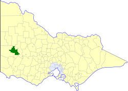
The Shire of Arapiles was a local government area in the Wimmera region of western Victoria, Australia. The shire covered an area of 2,342.62 square kilometres (904.5 sq mi), and existed from 1888 until 1995.
History
Arapiles was initially the West Riding of the Shire of Wimmera, as incorporated in 1862. It was severed and incorporated separately on 25 May 1888. It gained parts of Wimmera's South Riding on 30 May 1913.
On 20 January 1995, the Shire of Arapiles was abolished, and along with the City of Horsham and parts of the Shires of Kowree and Wimmera, was merged into the newly created Rural City of Horsham. The section west of Nhill-Harrow Road was transferred to the newly created Shire of West Wimmera.
Wards
The Shire of Arapiles was divided into three ridings, each of which elected three councillors:
- North Riding
- Central Riding
- South Riding
Towns and localities
- Clear Lake
- Connangorach
- Duchembegarra
- Grass Flat
- Jallumba
- Lower Norton
- Mitre
- Mockinya
- Mount Arapiles
- Natimuk*
- Noradjuha
- Nurrabiel
- Tooan
* Council seat.
Population
* Estimates in 1958, 1983 and 1988 Victorian Year Books.
References
External links
- Victorian Places - Arapiles Shire